
Apr 19, 2011
1
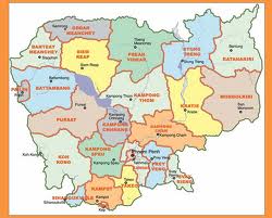
 Cambodia covers an area of 181,035 sq km (69,898 sq mi). Most of the country consists of a low-lying alluvial plain that occupies the central part of the country. To the southeast of the plain lies the delta of the Mekong River. To the east of the plain, ranges of undulating hills separate Cambodia from Vietnam. To the southwest a mountain range, the Chuor Phnum Krâvanh, fringes the plain and forms a physical barrier along the country's coast. Cambodia's highest peak, Phnom Aural (1,813 m/5,948 ft) rises in the eastern part of this range. To the north, the Chuor Phnum Dangrek mountains separate Cambodia from Thailand.
Land and Resource in Cambodia
Overview
Climate
Cambodia has a tropical monsoon climate. December and January are the coolest months, while March and April are the hottest. The country's rainy season extends from May to October. Average annual rainfall is about 1,400 mm (about 55 in) on the central plain and increases to as much as 3,800 mm (150 in) in the mountains and along the coast. The average annual temperature is about 27°C (about 80°F).
Plant and Animal
Forests cover 53 percent of Cambodia's land. The densest forests thrive in the mountains and along the southwestern coast. Higher plains and plateaus contain savannas covered with high, sharp grass. Plants growing in Cambodia include rubber, kapok (a tree with seeds that yield a cotton-like fiber), palm, coconut, and banana, all of which are exploited commercially.
Wildlife in Cambodia includes elephants, deer, wild ox, panthers, bears, and tigers. Cormorants, cranes, parrots, pheasants, and wild ducks are also found, and poisonous snakes are numerous. Logging and mining activities, along with unregulated hunting, have diminished the country's wildlife rapidly.
Natural Resource
Of Cambodia's total land area, only 21 percent is cultivated. Areas surrounding the Mekong and the Tônlé Sap are the most fertile regions. The country's once-ample timber resources have been poorly managed and are being rapidly depleted by local and foreign entrepreneurs. Although Cambodia is not rich in mineral resources, Batdâmbâng province in northwestern Cambodia contains limited quantities of zircons, sapphires, and rubies. The central part of the country contains commercial deposits of salt, manganese, and phosphate. The Gulf of Thailand is thought to contain petroleum deposits, but the extent and accessibility of the reserves have yet to be determined.
River and Lake
Cambodia's most important river is the Mekong, the longest river in Southeast Asia and the tenth largest in the world. The Mekong flows from north to south through Cambodia and is navigable for much of its course. Other rivers in the country include the Tonle Srepok and the Tonle Sab.
Cambodia's principal lake, the Tonle Sap (Great Lake), is the largest in Southeast Asia. From the northwest, the Tonle Sap drains into the Mekong via the Tonle Sab River, entering the Mekong at Phnom Penh. Each year during the monsoon season (approximately May to October), the waters of the Mekong increase and reverse the flow of the Tonle Sab, which begins to drain into the lake. The lake then expands dramatically, flooding the provinces along its banks. When dry weather returns, the river reverses its course again and flows back into the Mekong, draining the northwestern provinces. At the height of the flooding, the Tonle Sap reaches more than 10,000 sq km (4,000 sq mi), or about four times its size in the dry season. The lake is one of the richest sources of freshwater fish in the world.
Environment Issues
Deforestation is the most serious threat to Cambodia's environment. In the 1960s and 1970s Cambodian forests and wetlands were harmed by bombings and defoliants used in the Vietnam War. In the 1970s and 1980s the damage continued with the disastrous agricultural policies of the Khmer Rouge regime and civil war. In the relatively peaceful 1990s, timber became an important export for Cambodia. More than 800,000 hectares (2 million acres) of Cambodian forest were cut down from 1990 to 1995. In 1995 the government responded by banning log exports, but illegal timber exporting has led to continued deforestation.
Many of the mangrove swamps crucial to the country's fisheries and wildlife have been destroyed. The loss of wildlife habitat and the negative environmental effects of logging and mining industries have caused a decline in biodiversity.
In addition to banning the export of lumber, the Cambodian government has declared a large portion- 16.2 percent (1997)-of the country's total land area protected. The government has also ratified international environmental agreements pertaining to climate change, desertification, endangered species, marine life conservation, ship pollution, and tropical timber.
More info: www.mrd.gov.kh
Subscribe to:
Post Comments (Atom)

1 Responses to “Land and Resource in Cambodia”
April 19, 2011
It's good if the Royal Government of Cambodia can use and protect it proper!!!
Post a Comment
Leave your comment here if you have any comment or want to share your idea.... I really appreciate all your comments.